Once you got away from the major population centers, most of the roads had been rendered unusable. Roads that remained passable were to be avoided for fear of ambush. Therefore, the prevailing method of travel to and from the A-Team camps was by chopper. The photos below offer a look at Viet Nam from the Special Forces taxi -- a 'Huey'. And even though these photos are not part of a progressive sequence from any one chopper ride, they still illustrate the transition from sandy, coastal areas such as the Da Nang area to the rugged, jungle-covered plateau and mountains of the central highlands.
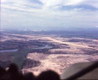
Notice the broad expanse of sandy soil with numerous ponds and river branches. The pilot is most likely following the coastline south
from Da Nang. Then, at a certain point, he will turn inland towards the SF camps in southern I Corps.
On many occassions we would sit on the floor in the open door of the chopper with our feet propped on the chopper's skids -- no seat
belts or anything. Flying along the coast at one or two hundred feet above the surfgave us a great view to see the sharks cruising the
area just beyond the surf. We would use the sharks for M-16 target practice as we flew overhead. It was great fun. Would I ride,
unrestrained, in the open door of a chopper now? No way!!
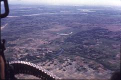
As the chopper ventured more inland, the ground conditions also changed.
See how the ground is changing? The sandy-type soil is giving way to 'normal' dirt. Notice, also, how the water is now fairly
restricted to the rivers as they wind their way to the coast.
As you gaze towards the horizon, you see less and less of the sandy soil... additional evidence that you were heading away from the coast.
The chopper continues its flight.
With most of the roads booby-trapped or damaged it is easy to see that the Vietnamese would turn to the waterways as transportation routes. In the southern areas of Viet Nam the waterways were the major modes of travel. The US maintained military units to deny the enemy the use of the waterways. These units used river patrol boats to intercept and combat enemy boats.
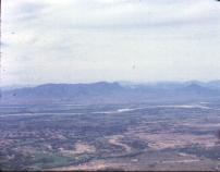
As the chopper heads inland, Viet Nam's 'highlands' begin to come into view.
The horizon now sports a different outline. You can see some of the features of the high plateau and the sharply-defined river
valleys.
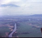
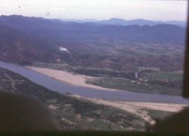
One of the rivers which empties into the South China Sea can be seen in the foreground -- halfway to the 'mountains'. This river most
likely originated in the high plateau area.

Approaching the highlands...
The ground is so flat that a river may take a very serpentine path to traverse the relatively short distance
from the highlands to the coast. What appears to be two rivers in this picture could actually be the same river.
You will also see some white clouds silhouetted against the 'mountains'... just above the handle of the M-60. Although difficult to see,
more of these clouds lie just over the ridge, to the right of pronounced 'hump' in the photo (slightly above and right of center). These
clouds were a common occurrence in the river valleys within the highland plateau. The Thuong Duc portion of the web site has some excellent
pictures of this fog/cloud effect.
Leaving the coastal plain behind...
You are looking at the leading edge of the highlands. One of the many rivers which drains the high plateau is breaking free of the plateau
on its course to the sea. Once released from the bondage of the plateau's river valley walls, the river is free to twist and turn --
almost as if it were groping to find the sea.
Most of the pictures in this web site portray the rivers of Viet Nam as docile natural elements... and indeed most of the time they were.
However, during the rainy season these rivers were beasts -- raging torrents of water that served as natural barriers to both SF and the NVA.
(See the story below)
This is one of those stories that you think might best be left untold.
It was during the rainy season. The ground had long ago lost its ability to hold more (rain) water. Every drop of rain that fell now was destined for the river. Company C sent us a message:"Intelligence sources indicate that a group of NVA/VC would be moving through a portion of your operational area. Go see what you can find out about this purported enemy activity."
The men of the A-Team did the correct thing and kept their opinion about 'military intelligence' to themselves. We had seen other examples of 'military intelligence'.
The Captain checked the proposed patrol route on the map and realized that the patrol would have to cross the river to reach the target area. The Captain radioed HQ and told them that we could not run the patrol. We were not equipped to cross the river. The river was currently about twelve to fifteen feet deep and had a thirty mph current!
Of course, a reply came back from HQ. "What do you mean 'You can't cross the river'? It's only an eighth of an inch wide on the map!", demanded the Major. The Captain responded that, if HQ didn't believe him, they could get their asses out here and see for themselves! The next day the Major arrived at the camp.
The Captain escorted the Major to the river so that he could see for himself. The Major waded into the river -- chest high -- before he would admit that we could not cross the river. When asked what supplies/equipment we needed in order to get across the river, the Captain provided a list of essential items -- rafts, several hundred feet of strong rope, oars, etc. "No problem", said the Major.
When the materials and equipment arrived a few days later, a quick inventory showed that we had received little of what we needed. The patrol was a definite "no go". By now the intelligence was days old, so the planned patrol was scrubbed.
To this day I am still flabbergasted at the 'its only an eigth-inch wide on the map' mentality.