A-103 Gia Vuc Location
Formerly a French outpostGia Vuc A-103 Location
French Outpost
Since history is (admittedly) NOT one of my stronger subjects, I may not have all of the following details correct. But here is the origin of A-103, as I understand it.(Attention - history buffs: Your input is requested.)Viet Nam was a French 'colony' for many years. (This is the "politically correct" way of saying that you invaded another country and maintain troops there to retain control.) Over the twenty years of occupation, resistance to the French began to grow. By the 1950's the resistance, lead by Ho Chi Minh, had become a formidable force. At the decisive battle of [Dein Bien Phu] the French were defeated and elected to abandon the colony idea. The cease fire agreement created a divided Viet Nam -- the Communist in the North and the democratic government to the South. As part of the French occupation the French had built armed outposts. The site at Gia Vuc was one of these French outposts.
Map details
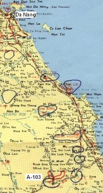
Note: Using my limited artistic skill I have tried to reduce/erase the freehand blue and red markings on this map. This
image was produced from a map I sent my mother while I served in 'Nam. I had used blue markers to show the approximate locations of Co C
A-teams and other locations I had been to. Additionally, I used a red marker to mark the approximate route of my last two patrols.
Gia Vuc was in the southernmost area of I Corp, strategically located on the road connecting the coastal region to the plateau towns of
Pleiku and Kontum. To the east and northeast were the important towns of Ba To, Minh Long, and Ha Tanh -- the location of A-106, A-108
and A-104 respectively. Quang Ngai, an important Viet Nam regional center, lay north of Ha Tanh.
Gia Vuc served an important intelligence-gathering role. Many of our patrols were intended to survey enemy movements to and
between the towns of Pleiku, Ba To and Kontum. The camp was located on elevated areas in the river plain, while the surrounding terrain was
mountainous and quite rugged. (You will note that many pictures of this portion of Viet Nam contain visible waterfalls. These features were
due to the sharp changes in vertical elevation.)
If you look closely at the map, you will note a distinct lack of towns and villages in the lower left quadrant. The area in the lower
left quadrant is part of the 'central highlands' area -- an area marked by a high plateau with steep sides giving way to low river valleys.
The mountains in this area rise out of this plateau. Other pages in this web site provide excellent aerial views illustrating the topography
of this region.